
SASKATCHEWAN
HWY 11 REGINA to SASKATOON remains under TRAVEL NOT RECOMMENDED ADVISORY.
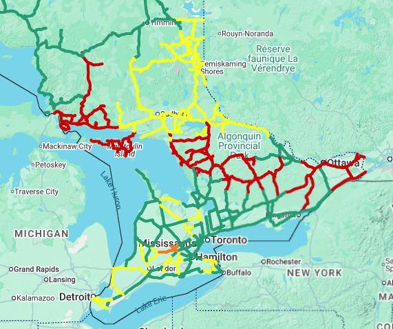
ONTARIO
GTA – severe thunderstorms, hail in the Guelph region and localized flooding on roadways are impacting travel this morning. This evening will bring a second round of similar weather. Delays in transport possible.
Northern Ontario – freezing rain and snow with up to 15cm possible. Regions along Lake Superior may see increased poor weather and road conditions.
Georgina Bay – freezing rain and ice pellets possible this morning and may intensify by evening.
Ottawa River Valley – rain and freezing rain – up to 30mm this morning and evening. Transportation delays possible due to hazardous road conditions. Power outages may occur.
QUEBEC
Freezing rain warning this morning and heading into the evening and may result in transportation delays. Up to 10mm possible. Road surfaces may be icy.
The following regions may be affected:
- Mauricie, Centre-du-Québec and Chaudière-Appalaches
- Outaouais, Laurentians, Lachute and Lanaudière
- Montreal, Montérégie and Centre-du-Québec
NEW BRUNSWICK
Freezing rain and ice build up expected for the province, continuing into Wednesday morning. Transportation delays expected, possible power outages, infrastructure and tree damage possible.
Northern regions of the province may also see significant snowfall and ice pellets. Hazardous road conditions likely.
NOVA SCOTIA
Ice build up and freezing rain expected and may result in prolonged power outages, transport delays and infrastructure / tree damage. Some areas may see significant snowfall of up to 25cm resulting in poor travel conditions.
PRINCE EDWARD ISLAND
Ice pellets, freezing rain and snowfall expected to intensify this evening and continue into tomorrow. Up to 2cm of ice accumulation possible and up to 10cm snow. Hazardous road conditions are expected and may result in transportation delays.
NEWFOUNDLAND / LABRADOR
Up to 15cm of snowfall expected into tomorrow over a 12 hours period. Transport delays possible and ferry crossings may be affected. The following regions are likely to be affected:
- southern Newfoundland from Port aux Basques to the Avalon Peninsula, including Clarenville and vicinity